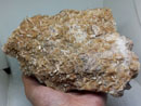
The Northern Pennine Orefield hasbeen for many centuries an importantsource of lead, industrial fluorite, and, toa lesser extent, zinc, iron, and bariumores. The earliest records of mining datefrom the 12th century, with the high pointof lead mining occurring in the 18th and19th centuries, followed by a rise influorspar production during the late 19ththrough late 20th centuries. Mineral specimenshave long been a byproduct ofthese mining operations. Known locallyas “bonnie bits,” they have been broughtfrom the mines as curiosities by miners,and can stil be seen decorating someyards and walls in the dale.
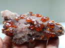
The Weardale area is particularlynoted for the production of many exquisite,well-crystallized specimens of fluoritewhich exhibit a strong daylightfluorescence. Fluorite specimens fromWeardale mines now grace most majormineral collections world-wide.

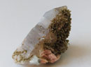
Fluorite, 7 cm high, from Blue Bell Pocket, Rogerley mine. Photographed in daylight. Spirifer collection.
By the early 1990s, large-scale commercialmining was in serious declinethroughout theWeardale area along withthe rest of the UK. As a result, the supplyof crystallized mineral specimens for thecollectors’ market as a byproduct of mininghas largely ceased. Those that domake it to market these days are for themost part recovered by weekend collectorsusing hand tools or recycled out ofold collections. The one notable exceptionto this has been the Rogerley Mine.
First discovered by local mineral collectorsaround 1970, the Rogerley Mine hasproduced a more-or-less steady stream of fluorite specimens over the past40 years. To this day, the Rogerley isunique as it is the only mine in the UKthat has been developed solely for the recoveryof crystallized mineral specimens.
LOCATION AND GEOGRAPHYThe Rogerley Mine (54°44’16.75”N,1°59’3.16”W) is located in the easternportion of the Weardale district, CountyDurham, Northern England. Weardale(“dale” is the local name for a river valley)runs East-West, following the courseof the River Wear, beginning at the borderbetween the counties of Durham andCumbria near Alston Moor and continuingeastward for more than 30 kilometers,past the town ofWolsingham.Whilethe area was at one time heavilyforested, much of this was cleared centuriesago, and the region is now predominantlyopen moorland divided bystone walls and the occasional stone cottage.
Inhabited towns and villages, forthe most part, occupy the valley floor,and Stanhope is the center of commercialactivity for the valley. Located a fewkilometers to the north of Stanhope isthe picturesque village of Rookhope,which was formerly the center of muchof the local mining activity.

Weardale landscape. J. Fisher photo.

One of the many remains of mining activity in Weardale – ore carts in Allenheads, today used as decoration of garden. J. Gajowniczek photo.

GaWeardale landscape. J. Gajowniczek photo.
The Rogerley Mine is situatedwithin an abandoned quarry of the samename, just east of the town of Stanhope.
The quarry was originally operated duringthe late 19th and early 20th centuriesas a source of limestone flux for localiron foundries that once operated in thearea. There is no evidence that thequarry was ever worked for lead orfluorspar, which were considered impuritiesin the limestone. When encounteredby the quarrymen, the galena andfluorite appear to have been discarded in a series of old waste piles which are nowheavily overgrown on the south side ofthe quarry.

Map of UK with location of Weardale area, and inset showing the Rogerley and other important Weardale mines.
GEOLOGY AND MINERALIZATIONThe mineral deposits of the NorthPennine Orefield are hosted by the Carboniferous-age sedimentary rocks (limestones,sandstones, and shales) thatmake up the North Pennine Mountains inthis part of northern England. Locatednear the top of the sequence of sedimentaryrocks is a unit known as the “GreatLimestone,” which has been found tocontain the majority of well-developedhorizontal, metasomatic replacements,known locally as “flats” in the Weardaleregion. Found within the Great Limestoneare three horizons at which theflats typically occur. These are known asthe Low, Middle, and High Flats Horizons.
The High Flats Horizon is usuallymost strongly mineralized of the threeand has historically been the source ofmuch of the high-quality fluorite specimensfor which the Weardale area isknown.
The Rogerley Mine follows a seriesof vertical fracture-filled vein and associatedmetasomatic flats. These mineralizedzones are part of the NorthPennines Orefield, which is a typical MississippiValley Type ore deposit. TheWeardale area appears to have been thecenter of mineralization in the orefield,spreading out into the adjacent areas ofTeesdale to the south, Allendale andNorthumberland to the north, and the AlstonMoor region of Cumbria to the west.
The majority of the workings at theRogerley Mine are developed followingthe main vein, known as the GreenbankVein, which trends northward from itsexposure in the Rogerley Quarry. Themain adit of the underground mine hasbeen driven following the vein within theHigh Flats Horizon. While crystal-linedcavities occaisionally occur within thevein itself, the best quality specimenshave been found in the flats that canoccur on both the east and west sides ofthe vein at this horizon.

Eastern Rogerley quarry, view from Rogerleymine. J. Gajowniczek photo.
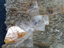
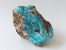
The mineralogy of both the flats andvein deposits is relatively simple, consistingof one or more generations of fluoriteplus or minus quartz and galena.
Carbonates including calcite and sideriteare occasionally found. The host limestonein and around both the vein andflats is often strongly altered to an ironrichgossan locally referred to as “ironstone.”
Pockets found in the vein areusually compact and discrete, where aspockets in the flats are actually an interconnectedseries of lens-like cavitieslined with fluorite, quartz, and galena.
Cavities in the flats are generally parallel to the bedding and often partially orcompletely collapsed and invariablyfilled with a very thick, sticky mud thathas infiltrated the cavities, likely brought in by meteoric waters subsequent to formationof the flats.


Two views of the Rogerley mine’s lower adit. Upper photo circa 1970, Greenbank photo archive. Lower photo 2010, J. GaWeardale landscape. J. Gajowniczek photo. jowniczek photo.


 YueGongAnBei 44051102000467
 |
|